

Missouri's Largest Man-Made Lake and Its Shoreline
Lake of the Ozarks is the largest man-made lake in Missouri and one of the most significant reservoirs in the American Midwest — a 54,000-acre body of water whose 1,150 miles of shoreline exceed the coastline of the state of California and whose creation through the impoundment of the Osage River behind Bagnell Dam in 1931 transformed a remote Missouri river valley into one of the most visited inland lake destinations in the United States.
The lake's extraordinary shoreline complexity, generated by the deeply irregular topography of the Ozarks plateau that the rising reservoir water filled across the valleys, hollows, and ridgelines of the original Osage River watershed, gives it a geographic character unlike most man-made lakes — a branching, cove-rich shoreline whose navigational complexity has given rise to the informal address system of "the mile marker" that Lake of the Ozarks residents use to locate properties along its winding length.
For Lake Ozark residents, Miller and Camden County families, and anyone seeking to understand the natural geography, engineering heritage, and recreational significance of one of Missouri's most distinctive landscapes, Lake of the Ozarks provides an essential and richly layered subject.
The Creation of Lake of the Ozarks
The Lake of the Ozarks came into existence as a direct consequence of Union Electric Company's decision to construct Bagnell Dam across the Osage River, a project that began in 1929 and was completed in 1931 at a cost of approximately $30 million — an enormous capital investment during the early years of the Great Depression that was justified by the hydroelectric power generation capacity the dam would provide to the growing Missouri and Illinois electricity markets.
The reservoir's filling displaced hundreds of families from the Osage River valley communities whose farms, homes, churches, and cemeteries were inundated as the water rose behind the dam across the months following its completion in 1931. The scale of the displacement and the transformation of the Ozarks landscape that the lake's creation produced represent the human and ecological dimensions of a water infrastructure project whose benefits to Missouri's electricity consumers came at a substantial cost to the communities whose land was condemned and flooded.
The Bagnell Dam history documents the engineering and cultural legacy of the structure whose impoundment of the Osage River created the lake that defines Lake Ozark's identity and economic character to this day.
The Shoreline's Geographic Character
The Lake of the Ozarks shoreline's extraordinary length relative to the lake's surface area reflects the deeply dissected topography of the Ozarks plateau, whose ancient karst geology — the limestone and dolomite bedrock whose dissolution over millions of years has created the caves, springs, sinkholes, and irregular terrain that define the Ozarks landscape — produced the intricate valley system that the rising reservoir water followed as it filled.
The lake's main channel follows the original course of the Osage River from the dam near Lake Ozark northwestward toward Warsaw, while dozens of tributary arms extend into the side valleys of the original watershed, creating the cove-rich shoreline complexity that gives the lake its distinctive navigational character.
The shoreline's development across the nine decades since the lake's creation reflects the transformation of what was initially a remote recreational landscape accessible only to those with the means and mobility to reach the Ozarks into a densely developed lakefront community whose residential properties, marina facilities, restaurants, and resort infrastructure give the shoreline its contemporary character.
The Lake of the Ozarks State Park preserves 17,441 acres of Ozarks landscape along the lake's southern arms, its trails, campgrounds, and natural shoreline character providing the undeveloped contrast to the broader lake's residential and commercial development.
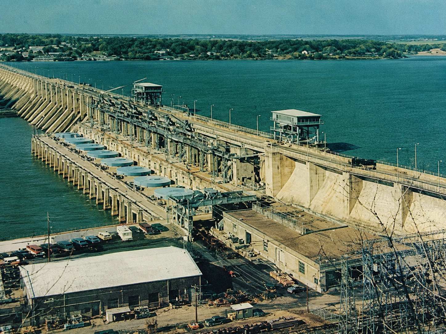
Image Credit: NPS, Public domain, via Wikimedia Commons
Recreational Uses and the Lake Economy
The Lake of the Ozarks recreational economy encompasses the full range of inland water recreation that a warm-water reservoir of its size and depth supports — the powerboating, water skiing, wakeboarding, fishing, and swimming that drive the summer visitor economy, alongside the sailing, kayaking, and paddleboarding that serve the lake's growing population of year-round residents whose recreational preferences extend beyond the motorized water sports that historically defined the lake's culture.
The fishing economy sustains a dedicated community of anglers whose pursuit of the largemouth bass, crappie, catfish, and white bass populations that the Missouri Department of Conservation maintains through active stocking and habitat management programs gives the lake a year-round recreational significance that extends beyond the summer peak season.
The marina infrastructure that has developed along the lake's shoreline — more than 100 marinas of varying sizes serving the powerboats, pontoons, and personal watercraft whose presence defines the summer lake experience — represents one of the most significant concentrations of freshwater marina capacity in the American Midwest and the physical infrastructure backbone of the recreational economy that sustains Lake Ozark's commercial character.
The U.S. Army Corps of Engineers documents the recreational management framework that governs federal reservoirs across the United States, the national program whose standards inform how inland lakes like Lake of the Ozarks manage the balance between recreational access and resource protection.
Missouri's Climate and the Lake's Seasonal Character
Missouri's continental climate gives Lake of the Ozarks its dramatically seasonal recreational and residential character, concentrating the lake's most intense visitor activity into the Memorial Day through Labor Day summer window when water temperatures, weather conditions, and the school-break calendar align to produce the peak season that sustains the majority of the lake's annual commercial activity.
Lake Ozark experiences a humid continental climate with hot summers averaging July highs near 89°F, cold winters with average January lows near 20°F, and approximately 43 inches of annual precipitation according to NOAA climate data for the Lake Ozark area. The summer heat that characterizes July and August along the Missouri Ozarks corridor creates the warm water temperatures that make the lake's swimming, tubing, and water sports most appealing to the metropolitan visitors whose presence sustains the peak season commercial activity of the surrounding communities.
The winter season delivers the lake's quietest period, when falling water levels — the result of the seasonal drawdown that Ameren Missouri conducts annually to create capacity for spring snowmelt and rainfall — expose the rock shelves, dock pilings, and shoreline features that summer water levels conceal, giving the winter landscape a dramatically different character that long-term residents recognize as the lake's annual seasonal transition.
The Shoreline's Environmental Significance
The Lake of the Ozarks shoreline represents one of Missouri's most ecologically significant freshwater environments, whose combination of warm water habitat, complex cove structure, and the tributary stream inputs from the surrounding Ozarks watershed sustains the aquatic biodiversity that makes the lake valuable both as a recreational fishery and as a wildlife habitat for the migratory waterfowl, bald eagles, great blue herons, and the osprey populations that the lake's fish-rich waters attract across the seasonal migration cycles.
The shoreline's ecological health faces the ongoing pressures of residential development, marina construction, and the boat traffic whose wake erosion gradually degrades the vegetated shoreline habitat that fish spawning and aquatic invertebrate communities depend on for their life cycles. The balance between the lake's recreational and residential development and the ecological health of its shoreline represents the central environmental management challenge that Missouri's lake stewardship organizations, the Missouri Department of Conservation, and Ameren Missouri navigate across the lake's management — ensuring that the water quality, habitat integrity, and fishery productivity that make the lake valuable for recreation are sustained across the decades of continued development pressure that the lake's appeal generates.
For Miller and Camden County residents and anyone exploring the natural geography, recreational significance, and shoreline character of Lake Ozark Missouri, the Lake of the Ozarks remains the most geographically complex, most ecologically significant, and most economically consequential natural resource in the Missouri Ozarks.
Related Posts